

Clouds are not just beautiful formations in the sky; they serve as critical indicators for weather forecasting. Understanding different cloud types can help predict rain, storms, and even temperature changes. But how are clouds’ shapes made? Let’s dive into the science behind cloud formation and their impact on the weather.
The Science Behind Cloud Formation
All clouds form through a process called saturation, where the air contains so much water vapor that it condenses into tiny liquid droplets or ice crystals. The shape and type of a cloud depend on various atmospheric conditions, including temperature, humidity, and wind patterns.
Common Cloud Types and Their Weather Signals
1. Cumulus Clouds: The Fair-Weather Clouds
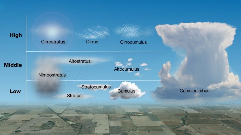
Cumulus clouds are the fluffy, white clouds that resemble cotton balls. These clouds typically form on warm, sunny days when the Sun heats the ground, causing warm air to rise. However, if the atmosphere is very unstable, cumulus clouds can grow into cumulonimbus clouds, which bring heavy rain, thunderstorms, and even tornadoes.
2. Cirrus Clouds: Wispy High-Altitude Indicators
Cirrus clouds are high-altitude clouds made of ice crystals. These thin, wispy formations are often seen ahead of a warm front and can signal an approaching change in weather. When cirrus clouds spread out from a thunderstorm, they form anvil-shaped anvil clouds, indicating severe weather activity.
3. Stratus Clouds: The Overcast Sky Makers
Stratus clouds form thick, uniform layers covering the sky. When these clouds are close to the ground, they create fog. If enough moisture is present, stratus clouds can produce drizzle or light rain, but when they develop into nimbostratus clouds, expect steady and prolonged precipitation.

How Mountains Influence Cloud Formation
Mountains play a significant role in cloud development. When air moves up a mountain slope, it cools and condenses, forming unique cloud types such as:
- Lenticular Clouds: These lens-shaped clouds look like flying saucers and form due to air flowing over mountain peaks.
- Banner Clouds: These clouds appear as streaks trailing from mountain summits, formed by strong horizontal wind currents.

The Role of Wind in Cloud Movement
Clouds move along with the wind, and observing different layers of clouds moving in various directions can provide insights into atmospheric conditions. Jet stream clouds, often at an altitude of around 6 miles (10 km), can travel at speeds exceeding 200 miles per hour (320 km/h), influencing global weather patterns.
Clouds are more than just sky decorations; they are essential tools for meteorologists and weather enthusiasts. By understanding different cloud formations, you can predict upcoming weather changes with remarkable accuracy. Whether you’re watching fluffy cumulus clouds on a sunny day or wispy cirrus clouds ahead of a storm, these formations tell a fascinating story about the atmosphere.
Leave a Reply