• Skip to main content
  • Skip to primary sidebar
  • Skip to footer
  • Home
  • About Us
  • Copyright Report
  • Submit Content
  • Terms
  • Privacy Policy
  • Legal Disclaimer

Hasan Jasim

Hasan Jasim is a place where you may get entertainment, viral videos, trending material, and breaking news. For a social generation, we are the largest community on the planet.

Here’s How Huge the Mississippi River Basin Actually Is

by Hasan Jasim Editorial Team Leave a Comment

ShareTweet

With its 3.2 million square kilometers (1,245,000 square miles) in area, the Mississippi Watershed is the largest drainage basin in North America, as evidenced below.
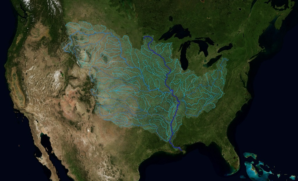
The Mississippi basin covers almost half of the USA. Image credit: NASA’s Scientific Visualization Studio

Yes, the Mississippi Basin is really that big. So big, actually, that it covers almost half of the USA’s continental landmass! (40%, to be precise)

The Mississippi River watershed is the 4th largest in the world, extending to 32 U.S. states and two Canadian provinces, from the Allegheny Mountains in the east to the Rocky Mountains in the west. Its diverse features, rich history, and heavy human demands have challenged water resource managers who must balance complex issues.

Aerial photo of the Mississippi River Basin Model, a large-scale hydraulic model that allowed engineers to simulate weather, floods and evaluate the effect of flood control measures on the entire system until 1971, when computer modeling took over. Source: US Army Corps of Engineers

Now, computer modeling of the Mississippi river system has come to a now milestone. NASA used a USGS database to trace the path of water from every point of the basin to the mouth of the Mississippi in the Gulf of Mexico. The database, which indicates the direction of water flow at each point, has allowed NASA’s Scientific Visualization Studio to assemble those directions into stream flows, as shown below.

The animation begins with the points that are farthest from the Gulf, revealing streams and rivers as a steady progression towards the mouth of the Mississippi until all the major rivers can be seen. The speed by which the rivers are revealed does not depend on the actual speed of the water flow. Instead, it proceeds at a constant velocity along each river path, timed so that all reveals reach the mouth of the Mississippi at the same time.

Animation: The Rivers of the Mississippi Watershed. Credit: NASA’s Scientific Visualization Studio

To give you an idea of how much water is “collected” by the river system:

  • At Lake Itasca, it would take 10 minutes for a 48 foot semi-truck trailer (3,600 cubic feet) of water to flow out of the lake into the Mississippi.
  • At St. Anthony Falls, the equivalent of 3 semi-trailers full of water go over the falls every second.
  • At New Orleans, the equivalent of 166 semi-trailers of water flow past Algiers Point each second.
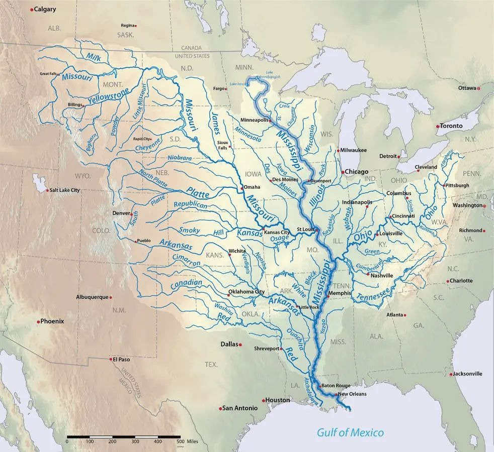
Detailed map of the Mississippi Watershed. Map: Shannon1, CC BY-SA 4.0 with data from USGS

The Mississippi River’s depth is less than 3 feet at the headwaters in Minnesota, whereas at the deepest section between governor Nicholls Wharf and Algiers Point in New Orleans it is 200 feet deep!

At least 260 species of fish, 25% of all fish species in North America, live in the Mississippi River. And 60% of all North American birds (326 species) use the Mississippi River Basin as their migratory flyway.

Let’s keep it that way!

Filed Under: Trends Worldwide Tagged With: actually, basin, here’s, huge, mississippi, River, trends, worldwide

Reader Interactions

Leave a Reply Cancel reply

Your email address will not be published. Required fields are marked *

Primary Sidebar

More to See

The Dog Can’t Get Out Of Her Mom’s Sweaters

By Hasan Jasim Editorial Team

Woman Is Delighted To Find A Wild Fox Sleeping Peacefully On Her Outdoor Sofa

By Hasan Jasim Editorial Team

The Stray Dog Will Not Stop Chasing The Bus Until The Driver Adopts Her

By Hasan Jasim Editorial Team

Unveiling the Universe Within: A 1.4 Petabyte Digital Map of the Human Brain

By Hasan Jasim Editorial Team

The Accidental Photographer: A Journey Through Nature with Andrew Suryono

By Hasan Jasim Editorial Team

The Great Pyramids of Giza: Unveiling Their Original Splendor

By Hasan Jasim Editorial Team

PHOTOS: A ‘Rainbow Cloud’ Was Sighted Over Loudoun County, Virginia

By Hasan Jasim Editorial Team

Footer

ABOUT HASANJASIM.ONLINE

Hasanjasim.online is a digital platform dedicated to publishing well-researched articles about the animal kingdom, nature, and the environment. Our editorial team works to source stories from credible outlets, scientific research, and verified reports, aiming to inform as much as we entertain. From wildlife conservation and animal behavior to natural wonders and environmental science, we cover the topics that help readers better understand and appreciate the natural world. Whether you're a lifelong nature lover or simply curious about the planet we share, Hasanjasim.online aims to be a trustworthy destination for stories worth reading — and worth citing.

Recent

  • Euphorbia Hirta (“Asthma-Plant”): What Traditional Use and Real Research Actually Show
  • A Mystery Animal Has Been Randomly Attacking People in New Hampshire — Here’s What We Know
  • A Woman Was Filmed Sharing Her Ice Cream With Her Dog — Here’s What Vets Actually Say About It
  • Dolphin Calf Incident in Ceuta Sparks Outrage After Disturbing Beach Footage Emerges
  • Lactuca Serriola Root: Traditional Uses of Prickly Lettuce (Wild Lettuce) Root
  • The Puppy a Firefighter Couldn’t Leave Behind — and the Story Didn’t End There
  • A Mother Dog Dove Into Floodwater Again and Again — Until All 7 of Her Puppies Were Safe

Search